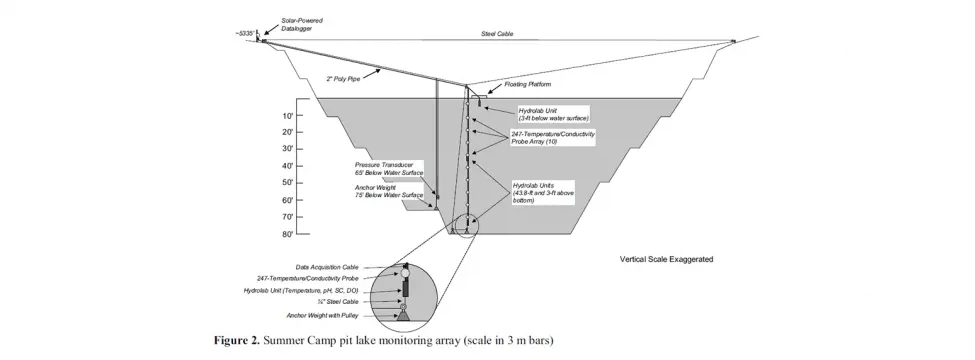
The Limnology Of Summer Camp Pit Lake: A Case Study
Publication - Published PaperAfter final closure of the Getchell Gold Corporation (GGC) Mine in northern Nevada, surface water bodies are expected to form in four pits.
Learn More
This website uses cookies to enhance browsing experience. Read below to see what cookies we recommend using and choose which to allow.
By clicking Accept All, you'll allow use of all our cookies in terms of our Privacy Notice.
Essential Cookies
Analytics Cookies
Marketing Cookies
Essential Cookies
Analytics Cookies
Marketing Cookies
After final closure of the Getchell Gold Corporation (GGC) Mine in northern Nevada, surface water bodies are expected to form in four pits.
Learn MoreThis Northwest Mining Association (NWMA) white paper documents the evolution of the federal and the Nevada state bonding requirements for hardrock exploration and mining projects.
Learn MorePrior to the existence of the first legal requirements to estimate a closure cost and provide financial assurance came into effect in the US in the mid 1970s, the primary use of closure cost estimates by the mining industry was to plan, budget & manage actual closure activities.
Learn MoreThe risk of long-term contaminant release from mine wastes probably poses one of the greatest risks to a mining operation.
Learn MoreLook into strategic mine planning, the process to get the right material out of the mine at the right time to obtain the lowest possible cost per unit of final commodity product in order to fulfill the business targets of the company.
Learn MoreIn the last two decades since the first modern gold heap leach facilities were closed, the approach to closure of heap leach pads has evolved considerably.
Learn MoreSaturated terrain and accumulated surface water are widespread across northern landscapes and cause local warming of the ground.
Learn MorePermafrost is defined as ground (soil or rock and including ice or organic material) that remains at or below 0°C for at least two consecutive years.
Learn MoreRecent advances in portable mapping devices and GIS software allow for the development of paperless workflows- enabling effortless capture, integration and interpretation of data in the field, and seamless integration of the field data in centralised exploration databases.
Learn MoreBetween 2012 and 2015, the resources industry experienced a downturn after a period of strong, sustained growth.
Learn More