During the first couple of decades of our professional life we have worked extensively with landslides risk assessment and monitoring in the European Alps, mostly in Switzerland and Italy.
At the beginning “risk” was not yet the buzz-word it became later. Clients and governments were seeing hazards impinging on population and infrastructure like transportation, hydropower and bulk-storage facilities. Engineering “repairs” were the most obvious paths.
Nevertheless, in 1997 Riskope’s founder Franco Oboni participated in an IUGS workshop in Honolulu. The goal of the event was to define a glossary of risk-related technical terms specific to slopes and landslides. In short, the IUGS Working Group on Landslides, Committee on Risk Assessment, produced a glossary for quantitative risk assessment for slopes and landslides. The glossary of risk-related technical terms has continued to evolve. It is now applicable to other fields of business and industries and the latest version is freely available online.
Discussing landslides risk assessment and monitoring
Today we return to our “first love” to discuss a few points related to landslides risk assessment and monitoring.
One of our latest books is:
- Di Capua, G., Bobrowsky, P.T., Kieffer, S.W. and Palinkas, C., 2021, Geoethics: Status and Future Perspectives. Geological Society, London, Special Publications, 508(1), pp.NP-NP.8,
And our chapter in that book is “Holistic geoethical slope portfolio risk assessment”. We endeavour to show how sustainability and ethics can be fostered by using rational, repeatable, transparent quantitative risk assessment applicable at the local scale as well as on a large scale. Among the case histories we present, one deals with the Cassass landslide in North Western Italy.
A few references on the Cassass landslide
Before the book cited above came out, we published various papers on the Cassass Landslide and the studies we performed. The related references below in chronological order.
- Oboni, F., Angelino, C. , Moreno, J. Using artificial intelligence in an integrated risk management program for a large alpine landslide. International Conference ‘Climate Change – Challenges and Solutions’, May 21-24th 2007, Ventnor, Isle of Wight, United Kingdom. Thanks to our friend Jordi Moreno we explored possible use of AI within an integrated risk management program where the probability of brutal accelerations was predicted as a function of antecedent rains.
- Oboni, C. Angelino, B. Visconti. The Cassas Landslide and its impacts on an international & Olympic transportation corridor: studies, monitoring, solution and crisis plans, Second World Landslide Forum – 3-7 October 2011, Rome. In this paper we discussed how monitoring, predictions and careful considerations related to consequences lead to the design of a mitigation system. Finally,
- Oboni, F., Oboni, C., The Long Shadow of Human‐Generated Geohazards: Risks and Crises, Geohazards Caused by Human Activity. Prof. Arvin Farid (Ed.), InTech, ISBN 978-953-51-2802-1, Print ISBN 978-953-51-2801-4, November 30, 2016. In this freely downloadable book our chapter, and in particular section 3.1.2 and following present a synthesis of the same case history.
Space observation new tools
At Riskope we have used space observation results such as:
- Interferometric Synthetic Aperture Rada (InSAR),
- Normalized Difference Vegetation Index (NDVI);
- Normalized Difference Water Index (NDWI);
- Normalized Difference Moisture Index (NDMI) and finally
- Short wave infrared composite (SWIR)
for a number of cases in the mining industry and landslides and/or man-made slopes. Here are a couple of references.
- Oboni F., Oboni C., Angelino C., Recent Experiences Using Space Observation for Quantitative Risk Assessment of Tailings Dams, Tailings and Mine Waste 2021, Banff, AB, November, 2021.
- Oboni, C.H.Oboni, R.Morin, S.Brunke, C.Dacre., Space Observation, Quantitative Risk Assessment Synergy Deliver Value to Mining Operations & Restoration, (see the presentation) Rouyn-Noranda, 2018, Symposium on Mines and the Environment, Rouyn-Noranda, Québec, June 17 to 20, 2018.
In those papers we already cautioned users on a few issues we have encountered. Happily, we were working with experienced and friendly suppliers that not only helped us solve the issues, but also pointed out possible “traps”, potentially leading to hazardous misinterpretations.
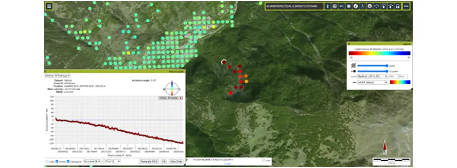
So, we approached with keen interest the newly published and publicly available European Ground Motion (EGM portal https://land.copernicus.eu/pan-european/european-ground-motion-service manual: https://land.copernicus.eu/user-corner/technical-library/egms-end-user-interface-manual ).
We looked at the Cassass Landslide (Loc 45.06567, 6.90520) between the beginning of November 2016 and November 2020.
The image below shows an example of the results the platform delivered.

