Planning for an uncertain climate future is now an essential part of risk management. Heavy rain has been implicated in approximately 25% of global and 35% of European tailings dam failures, according to a study published in the Journal of Hazardous Materials in 2008.
In particular, climate considerations in tailings management has been brought into focus by the publication of the Global Industry Standards on Tailings Management. The standard states that the knowledge base related to each tailings facility should ‘capture uncertainties due to climate change’.
One of the key parameters included in climate change analysis is precipitation and precipitation trends. It has been observed that short-duration high intensity events have become more frequent in some areas of the world. A warmer climate increases the amount of energy in the atmosphere and water evaporating into the air. This moisture can then converge into a storm system driven by increasingly energetic atmospherics producing more intense precipitation.
However, before we link all extreme weather to global warming, we must be clear that the climate is inherently chaotic. It is difficult to disentangle natural variability and climate change and every event perceived as extreme may be the result of natural processes, rather than anthropogenic climate change.
For several years SRK has been developing site-specific future climate estimations based on General Circulation Models (GCMs), a class of computer-driven models normally used for weather forecasting, understanding climate and projecting climate change, also commonly called Global Climate Models. Data for the assessments are derived from the NASA Earth Exchange Global Daily Downscaled Projections (NEX-GDDP-CMIP6) dataset comprising climate scenarios for the globe derived from 35 GCMs. Variables available in the NEX-GDDP-CMIP6 dataset have a daily time resolution.
Although the future short-term and long-term implications of changing climate conditions can be projected, much of the future change will depend on actions the global community takes in response to the crisis. For this reason, the Intergovernmental Panel on Climate Change (IPCC) has established shared socioeconomic pathways (SSPs). These SSPs correspond to different geopolitical responses. For example, SSP1-1.9 assumes a rapid and globally simultaneous transition away from fossil fuels, with an increase in health and wellbeing, whereas SSP3-7.0 assumes a continuation of the current global emissions trend and a shift to countries competing with each other over national security and resources. From these hypothetical futures, the IPCC has estimated the resultant concentrations of greenhouse gases in the atmosphere over time, referred to as Representative Concentration Pathways (RCPs).
The SRK product uses the state-of-the-art models developed for the 2021 IPCC sixth assessment report (AR6) to assesses future changes under two of the four pathways, SSP2-4.5, which is a medium emissions future that assumes climate protection measures are being taken by all nations, and SSP5-8.5 a scenario that represents the most conservative case (the worst case scenario). The data span the entire globe with approximately 25km spatial resolution using historical data for the periods from 1950 through 2014 and climate projections from 2015 to 2100.
Climate change modelling for projects or mine sites is conducted through a compilation of available GCMs and by completing analyses of multiple climatic models with a purpose-built script developed by SRK using R, a programming language for statistical computing and graphics. The results of these analyses provide an estimate of the expected change of different climatic parameters for a specific location on the globe, defined by its coordinates representing the mine site.
The analysis of GCMs considers anomalies, or potential change, up to 2100 relative to the historical baseline period 1985 – 2014, or the last 30 years of the historical baseline which can be considered as the benchmark for ‘current’ climate conditions.
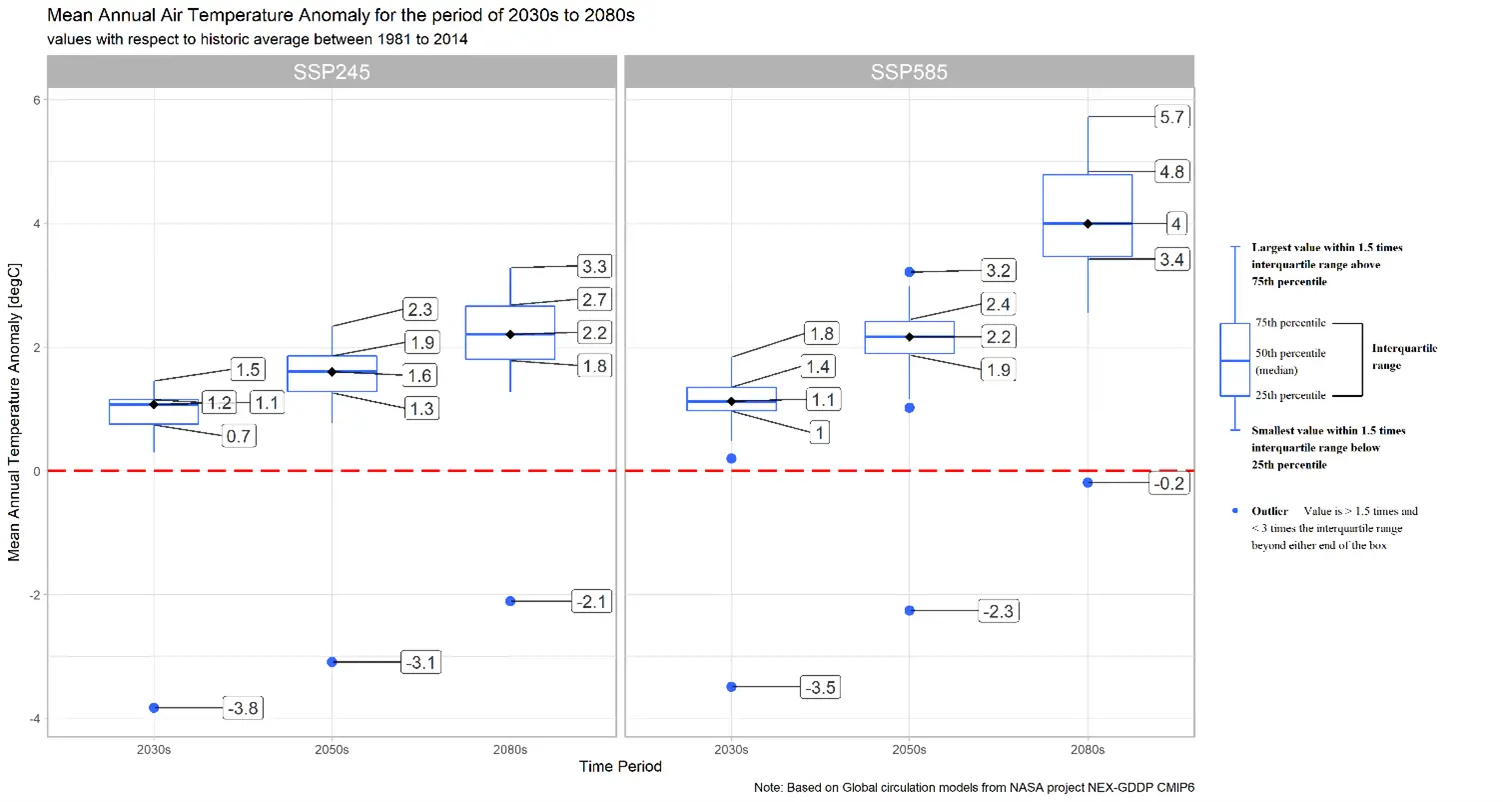
The SRK R script captures daily climate parameters across the historical period until the end of the century. Analyses then review GCMs over mine specific time periods. For example, in the case illustrated in Figure 1, the first assessment period covers 2020–2049, a period that includes the operational mine phase. Climate changes during this period are most likely to influence operational design and management. The second assessment period represents the period from 2070 – 2099, which predicts the future climate until the end of the 21st century. This period reflects possible climate changes that may influence the latter years of operations as well as closure design and post-closure monitoring.
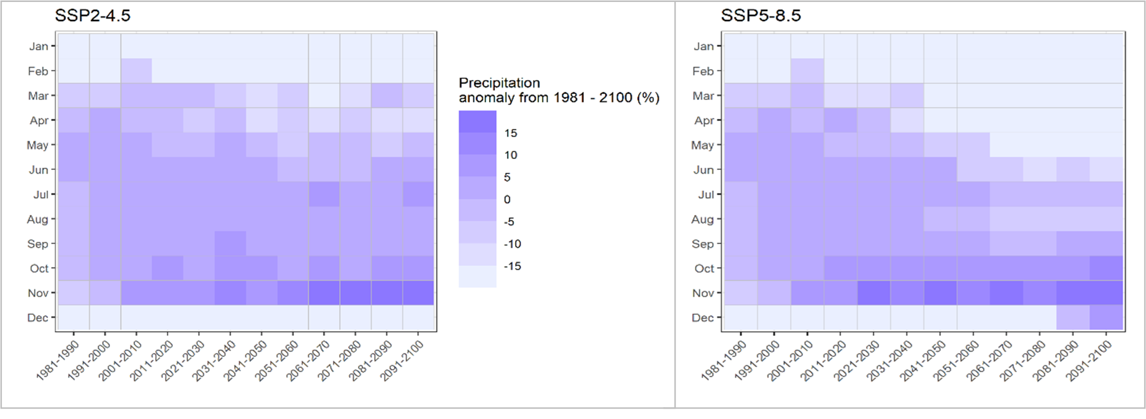
One key output of the analyses is statistical representation of all the GCMs for defined time periods including the median value and the possible range of change. The results can also graphically represent seasonality using heatmaps developed to understand monthly projected changes on decadal time resolution (Figure 2). This is useful to inform water balance and mine infrastructure design which is particularly useful on mine sites that rely on storm water supply.
As an inherently chaotic system, one thing alone is certain, that the climate will continue to change. Whether large or small, underground or open pit, changing weather will become an increasingly important risk factor for mines around the world. Managing that risk to limit the impact on operations, stakeholders and the environment will need as much focus from the mining and investment communities as measuring and reducing greenhouse gas emissions going forward.


