In October 2020, SRK Exploration was commissioned by MunAmco Pvt. Ltd. (MunAmco) to provide strategic advisory services with respect to their exploration programme on licences covering the historical ‘Golden Oriole’ and ‘Tommy’s’ underground gold mines, together the ‘Esigodini Project’, in southern Zimbabwe. These mines, which lie within the Bulawayo-Filabusi Greenstone Belts, had operated commercially until the late 1980s before being abandoned due to political circumstances and the falling gold price.
MunAmco was in possession of several mining and exploration plans from the historical operations, including the locations of shafts, adits, stopes and production assays at Golden Oriole. These plans were captured into a GIS workspace and digitised in 3D modelling software to produce wireframe models of underground mining infrastructure and grade models for the gold mineralisation, which followed a granitoid-hosted mesothermal vein system. Mining depletion up to the date of the plans was also accounted for, which reconciled well with historical approximations of production at the mine. The model created enabled range-based grade-tonnage estimates and the calculation of in-situ values for the remaining mineralisation.
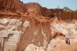
Following the initial desktop study, a reconnaissance field visit was organised to verify the locations of features referenced in the historical plans and to conduct preliminary surficial litho-structural mapping of the near-mine areas. An SRK Exploration geologist travelled to site, negotiating COVID pandemic restrictions to complete a four-day work programme. The mapping successfully delineated strike-extensions to the main mineralised ‘reefs’ at Golden Oriole and Tommy’s, as well as identifying several other mineralised veins at surface which were not included on historical maps or plans. Structural data on the orientation of these veins and several grab samples were collected, some of which returned assay results indicating low-grade gold mineralisation. The positions of historical mining features and drillhole collars from a recent phase of MunAmco drilling were confirmed, and the extents of significant artisanal mining activity in the alluvial/colluvial material proximal to the ‘hard-rock’ mineralisation were also mapped.
The field mapping data was incorporated into the geographic information system (GIS) and 3D workspaces and was used to refine the position of georeferencing features, and to update and extend the modelled wireframes at Golden Oriole. A preliminary 3D geological model was also constructed for the Tommy’s mineralisation, which was used to troubleshoot issues with the previous MunAmco drilling programme. The mapped extents of artisanal exploitation at surface were also used to infer range-based grade, tonnage and in-situ value estimates for the alluvial/colluvial gold mineralisation.
SRK Exploration presented MunAmco with a drilling programme designed to test down-dip and along-strike extensions at the Golden Oriole mine. SRK Exploration also highlighted the potential value of the alluvial/colluvial mineralisation mapped on site, which offers an opportunity to initiate a low CapEx starting operation that could part-fund hard-rock exploration at the Project. MunAmco acted on these recommendations and, as of mid-2022, has initiated gold production from its surficial assets.


.webp)